










Welcome
Welcome to the Land East of Birmingham Road, Stratford-upon-Avon website and thank you for visiting to find out more about the proposals.
The Site forms part of draft allocation STR.1, known as The Clopton Quarter, within the emerging South Warwickshire Local Plan (SWLP). In this context, an outline planning application is being prepared for up to 90 new homes and public open space on Land East of Birmingham Road, Stratford-upon-Avon.
Our vision is to create a high-quality residential development, which will include a mix of house types and sizes, including affordable homes to help meet local needs. The proposed development will be landscape-led, incorporating green spaces and planting throughout the Site, and will be in keeping with the local character.
-
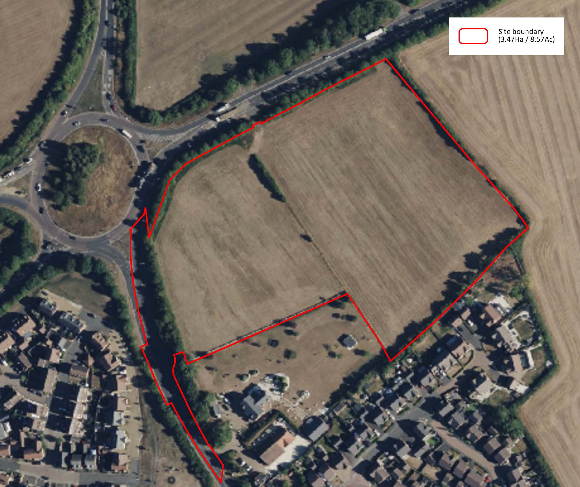
Site Boundary Plan (click to enlarge)
About Rainier Developments
Rainier Developments are a privately owned land and development company, who work jointly with landowners, key stakeholders, local authorities and developers to create high-quality developments, built with both the present and future needs of local communities in mind.
Rainier Developments welcome this opportunity for engagement and feedback from you so that your comments may influence the design process at this formative stage before any planning application is made. This website provides background information to the proposed development, including the local planning policy context, as well as providing plans which illustrate how the development could come forward.

About The Site
The Site lies within Stratford-on-Avon District, immediately adjacent to Stratford-upon-Avon's northern edge. It is located approximately 2.3km (approximately a 10 minute bus ride) from Stratford-upon-Avon Town Centre.
The Site comprises of two fields and has a total area of 3.47ha. The Site is bordered by mature trees and hedgerows along its northern and western sides, separating it from the A46 and Birmingham Road, with private gardens to the south and agricultural fields to the east. There is existing residential development to the south and east of the Site.
The Site is ideally located to benefit from regular transport connections. The Stratford-upon-Avon Parkway station is 650m (9 minute walk) from the Site's access, providing regular connections to Stratford-upon-Avon, Leamington Spa, Birmingham, Worcester and Kidderminster. Bus stops along Birmingham Road benefit from bus services seven days a week, connecting the Site to Stratford-upon-Avon, Henley-in-Arden and Solihull. Options for active travel, by walking, wheeling or cycling for example, connect the Site to services and facilities along Birmingham Road and the local area.
In planning terms, the Site is considered to be grey belt land. This term is used to describe land within the designated Green Belt that is considered to have lower environmental, landscape or strategic value. This can include land that visually contained, is less connected to the wider countryside or has been previously developed.
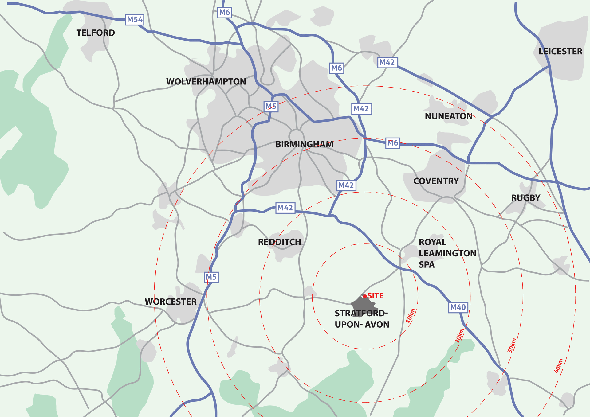
Our Vision & Proposals
Rainier Developments aim to deliver up to 90 new homes, including affordable housing to help meet local needs. These new homes would include a mix of housing types and would be designed to meet high sustainability standards.
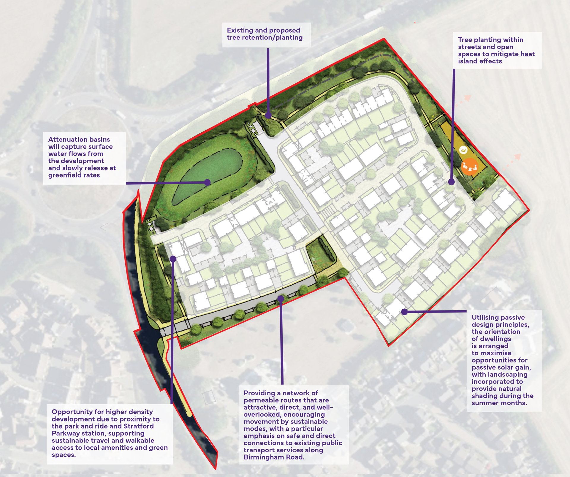
The new homes would be set within new green spaces, with planting to enhance the site's existing landscaping. Existing trees and hedgerows would be retained where possible, and incorporated into the layout of the Site.
These new green spaces will also include a childrens play area, walking routes and space for nature. Access to the Site will be from Birmingham Road and will include walking, cycling and vehicle access. Movement throughout the Site will be via a hierarchy of streets, providing space for active travel as well as vehicles.
Technical Details
As part of the proposals, Rainier Developments are working with specialist consultants to assess the Site and its context, to make sure that the development is technically deliverable. This work has included looking at:
Highways & Access
The proposed development will be accessed from Birmingham Road (A3400) via a new junction designed to provide safe and convenient access to the Site. New walking and cycling routes will also be created, linking directly to the existing shared path network along Birmingham Road and providing connections towards Bishopton Lane and the surrounding area.
The Site is well connected to local public transport. The nearest bus stops, located on Birmingham Road just a three-to-four-minute walk away, are served by regular services to Stratford-upon-Avon, Solihull and nearby communities. Stratford-upon-Avon Parkway Railway Station is also within easy reach, approximately an eight-minute walk or three-minute cycle from the Site, providing convenient rail connections for residents and visitors.
Walking and cycling will be an attractive option for many everyday journeys. The Site is surrounded by a network of shared paths that connect to local facilities, services and residential areas, while a continuous route along Birmingham Road provides access to Stratford-upon-Avon Town Centre. Most destinations across the town can be reached within a short cycle ride.
Overall, the Site is in a highly accessible location, giving future residents a range of convenient travel choices and making it easy to walk, cycle or use public transport for everyday trips.
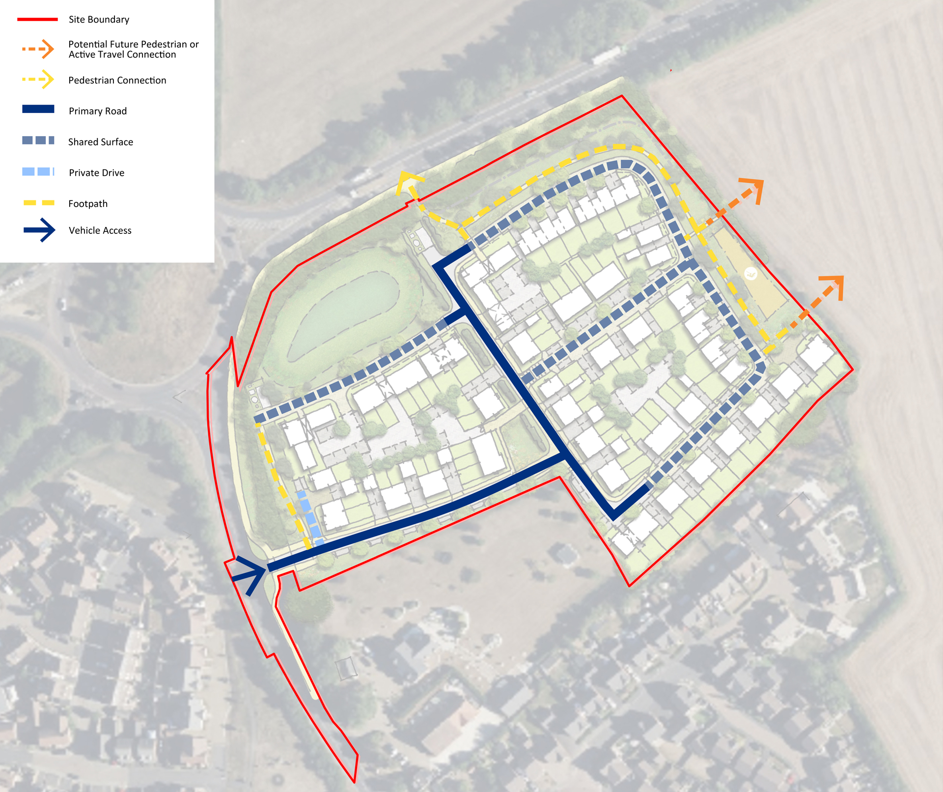
Ecology
Ecological surveys have been undertaken to understand the habitats and wildlife using the site. Most of the site consists of intensively managed, species-poor grassland, although its boundary hedgerows and trees provide more valuable habitats and connections for wildlife. Surveys have considered bats, badgers, reptiles, birds and great crested newts. No reptiles were recorded, nearby ponds were dry and unsuitable for breeding great crested newts, and no badger setts were found. A number of bat species use the site, principally around its hedgerows and trees, and one tree has features that could potentially be used by roosting bats.
The proposals are therefore being designed to retain and strengthen the important hedgerows, trees and wildlife corridors. New native planting, species-rich grassland, scrub, sustainable drainage features and approximately 190 metres of new hedgerow would create additional habitats. A sensitive lighting strategy would protect darker routes used by bats, while bird and bat boxes could provide further nesting and roosting opportunities. The development will be required to achieve at least a 10% biodiversity net gain, with the new and enhanced habitats managed and monitored over the long term.
Trees
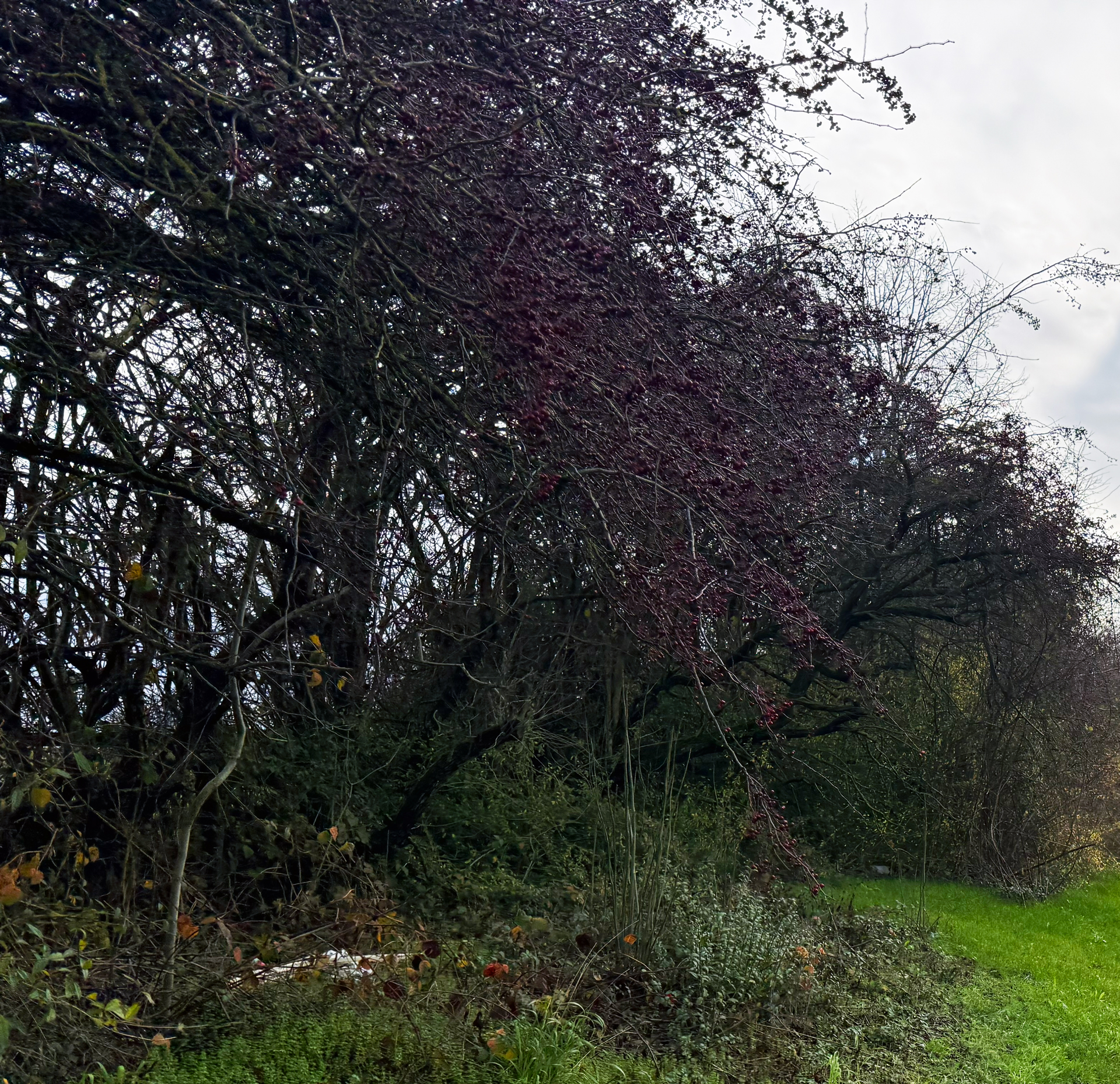
A detailed survey has recorded the trees, hedgerows and other woody vegetation within and around the site. Most of these features are located along its boundaries and are of relatively low quality, although five groups or individual features have been assessed as being of moderate quality. These are mainly around the edge of the site and will be prioritised for retention. None of the surveyed trees is protected by a Tree Preservation Order, and the site is not within a conservation area.
The proposals will seek to retain existing trees and hedgerows wherever practicable and position new development outside the areas needed to protect their roots and canopies. Suitable protection would be installed during construction, and new tree and hedgerow planting would reinforce the site's boundaries, provide wildlife habitat and help integrate the development into its surroundings. A detailed assessment will accompany the planning application and confirm how retained trees would be protected.
Landscape
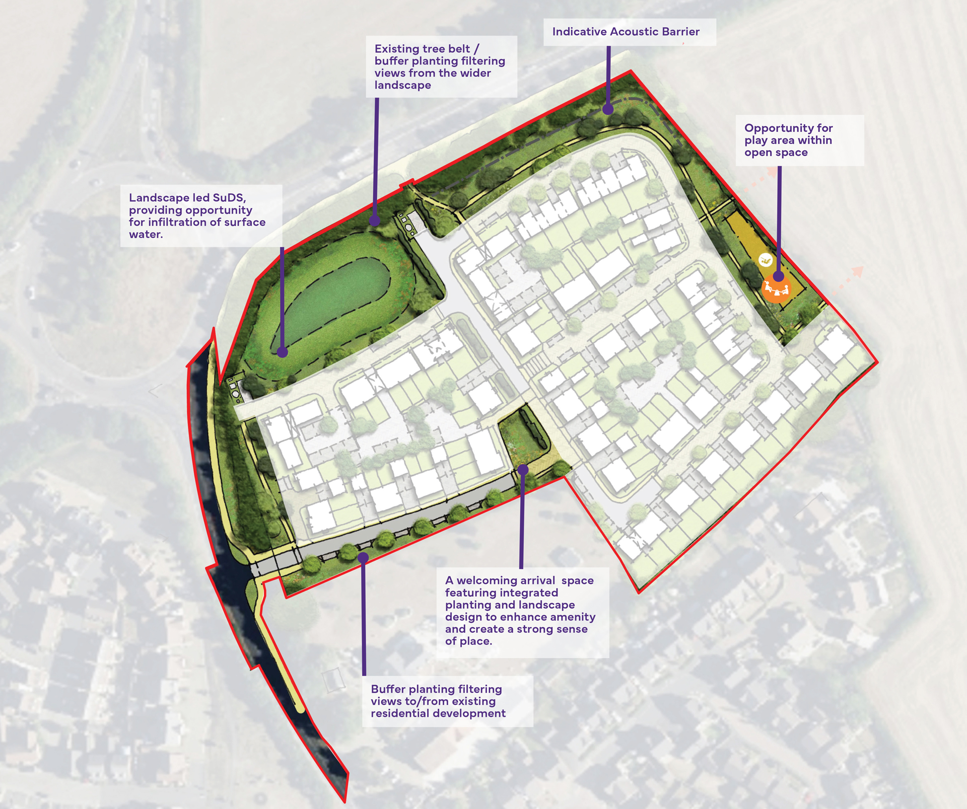
The site lies on the northern edge of Stratford-upon-Avon, between Birmingham Road and the A46. Although it currently comprises two grassland fields, its character is already influenced by the adjoining roads, highway infrastructure and nearby housing. The proposals are being developed as a landscape-led extension to the town, retaining and strengthening the existing boundary trees and hedgerows wherever possible. New homes would be focused principally within the central and southern parts of the site, with public open space and new planting creating a softer transition to the countryside to the east.
The development would change the appearance of the site and would be visible from some nearby homes, roads and public footpaths. However, the assessment finds that these effects would be largely localised because views from the wider area are limited by existing development, woodland, vegetation and the surrounding landform. New trees, hedgerows, wildflower areas and other landscaping would help soften the development as they mature. The proposals would also provide new walking routes and connections to the surrounding footpath network.
Flood Risk
The proposed site is identified as lying outside of the fluvial and tidal flood risk zone, according to the Environment Agency's (EA) published flood map for planning. The EA information indicates that the level of flood risk to the site corresponds to a Flood Zone 1 - low probability of flooding. This flood zone has less than a 1 in 1000-year annual probability of flooding. The National Planning Policy Framework Planning Practice Guidance states that all types of development are suitable for this flood zone.
Within the site, an area of low - high risk of surface water flooding is shown within the south-west corner of the site. However, following further assessment, it is considered that the risk of flooding does not pose a significant constraint to the site, with the development alleviating the risk through the inclusion of a site wide drainage strategy.
No other sources of flooding have been identified which pose a significant risk to the site, this includes flooding from groundwater, existing sewers and artificial sources.

Drainage
Surface Water
Current legislation and guidance require developers to manage surface water run-off from new development, to mitigate flood risk to the site and surrounding area and to provide a sustainable means of disposing of run-off from impermeable areas of the site. Surface water run-off from the new development should be managed via the design of a sustainable drainage system (SuDS). The possible drainage options considered for the site include the use of infiltration methods and discharging to a local watercourse or public sewer network.
The preferred method for the disposal of surface water flows is via the use of infiltration techniques followed by discharge to a local watercourse. However, the use of infiltration methods is unlikely to be suitable due to the characteristics of the underlying strata, with no suitable watercourse identified within the site or nearby vicinity. Consequently, an alternative strategy of discharging flows to the existing public surface water sewer network is considered the preferred option. This option will include attenuating flows before being discharged to the existing sewer at a restricted pre-development greenfield rate.
Foul Drainage
A new foul drainage network will be constructed throughout the proposed site to service the development proposals. The new network will collect and convey foul water discharge from the development to the existing Severn Trent Water public sewer network within the nearby vicinity of the site.
Noise
Noise conditions across the site are influenced primarily by road traffic on the A46, Bishopton Roundabout and Birmingham Road. A detailed noise survey and computer noise modelling have been undertaken to understand these conditions and to inform the evolving layout of the development.
The masterplan is being developed to provide suitable noise conditions for future residents through the arrangement and orientation of buildings, appropriate separation from surrounding roads and acoustic screening where required. Internal noise will also be considered through the detailed design of building façades and ventilation. A Noise Assessment setting out the assessment and proposed approach will accompany the planning application.
Heritage
The site contains no listed buildings, scheduled monuments or other designated heritage assets. The assessment has also considered nearby listed buildings, including Clopton House, Bishopton Lodge, The Limes and The Lodge. These buildings are separated from the site by distance, existing development, roads and vegetation. The site does not contribute to their historic significance or the way in which they are experienced, and the proposals are not expected to cause harm to them.
There are no previously recorded archaeological remains within the site, and the site survey found no visible features of archaeological or heritage interest. There may be limited remains associated with its past agricultural use, such as former field boundaries or ploughing, but these would be of low significance. If required by the council, any potential remains could be investigated and recorded through an appropriate programme of archaeological work before or during construction.
Sustainability
Building sustainably is a key feature of delivering new homes and this relates to both the location & design of new development.
New homes which are sustainably located are well connected to public transport networks and local facilities to reduce the need to travel by private car. The Site at Birmingham Road is well connected to existing bus routes and is within 800m of the Stratford Parkway Train Station. Improvements throughout the proposed development will make it easier to travel by foot or by active transport to further reduce the need for single occupancy car journeys.
While the detailed design of the proposed new homes will be agreed at a later stage, the homes will include a range of principles to contribute to their long term sustainability. These include, for example:
- Compliance with the Future Homes Standard;
- Electric Vehicle charging points provided on all new homes;
- The use of high quality materials and techniques during construction minimise heat loss, maximise insulation and utilise heat recovery;
- Utilising new technologies to improve energy and resource use, improving the power and water efficient of the new homes; and
- Enhancing and creating new habitats across the Site to deliver at least a 10% increase in biodiversity net gain.
Why Now?
The Council, in conjunction with Warwick District Council, have been preparing a new, emerging Local Plan, the South Warwickshire Local Plan (SWLP). Upon adoption in 2028, this Plan seeks to meet South Warwickshire's sustainable development needs and strengthen local communities to 2050.
The Councils have recently consulted on the latest version of the SWLP. This is referred to as the Regulation 19 Plan and included detail on the proposed spatial strategy to direct development to sustainable locations in South Warwickshire.
The Site has been included in this version of the emerging South Warwickshire Local Plan (SWLP) within draft allocation STR.1, also known as The Clopton Quarter. The Site, along with land to the east and at the Park & Ride, has been assessed and considered by the Councils to be a suitable location for sustainable residential development.
This planning application is being submitted in response to pressing national and local housing situations.
At a national level, the Government has set ambitious housing targets to address a shortage of homes nationally, with legislation and planning policy placing an expectation on local authorities to boost supply in their areas. The National Planning Policy Framework (NPPF) contains policies to support the delivery of a substantial increase in the supply of homes.
At a local level, Stratford-on-Avon District Council is unable to demonstrate a five year supply of housing land, which is required through national policy. The lates published figures confirm that the Council have 2.21 years of housing land supply and a calculated need of 1,112 new homes per year.
In addition to this, the Council does not currently have an up to date Local Plan in place, which limits its ability to demonstrate that enough land has been allocated to deliver a supply of housing to meet the identified local need.
As the Council are unable to demonstrate five years of housing land supply, as required by national policy, and the Local Plan is considered out of date, the presumption in favour of sustainable development is triggered.
In this context, bringing forward the development proposal now represents a necessary response to local housing need and national policy objectives in location that the Council have indicated is suitable and sustainable for development.

Next Steps
Rainier Developments will be submitting an outline application for planning permission. This seeks approval from the Council as Local Planning Authority on the principle of residential development at the Site and its access.
Before making a decision, the Council will consult with neighbours and statutory consultees on areas such as highways, ecology, flood risk & drainage and other local infrastructure requirements. The Local Planning Authority will then consider whether the scale and nature of the proposed development is acceptable, with regards to the Site's context, proposals and technical information.
Subject to outline permission being granted, a reserved matters application can then be submitted. This will include more detail on the layout, landscape and the appearance of the new development. There will be further public consultation in the preparation of the reserved matters application. An approximate timeline is below:
- Public Consultation: Autumn 2026
- Planning Application Submission: Autumn 2026
- Planning Committee Determination: Spring 2027
- Anticipated Reserve Matters: Autumn 2027
- Anticipated Start on Site: 2028
- Anticipated Completion: Summer 2030
Have Your Say
Rainier Developments would like to know your views on the proposals for the Site and we welcome your feedback.
All thoughts, suggestions and feedback received will be carefully considered to help inform the proposals in advance of the submission of an outline planning application.
Feedback can be provided via:
- The online form below
- Email: cloptonquarterstratford@stantec.com
- Post: Land East of Birmingham Road, Pegasus Group, 5th Floor, 1 Newhall Street, Birmingham, B3 3NH
Please share your feedback by 15/11/2026. Once the application has been submitted, the Council will also formally consult neighbours and statutory consultees, requesting further views on the scheme.
Thank you for taking the time to review our proposals, we look forward to receiving your comments.
We take data protection seriously. Please only provide your personal details if you are willing for them to be used by Stantec and the project team for the purpose of research in connection with this project and in order to update you on the progress of the project. Your details will be treated as confidential and will not be shared, passed on or used by any third parties and they will only be retained until the end of the planning process for the project, after which time they will be deleted. At any time, if you wish to withdraw consent to the processing of your personal data, you may do so by emailing: cloptonquarterstratford@stantec.com
Contact Us
If you have any comments or questions or would like a hard copy of any of our consultation materials, please contact us.
Send us a message and we will get back to you as soon as we can: